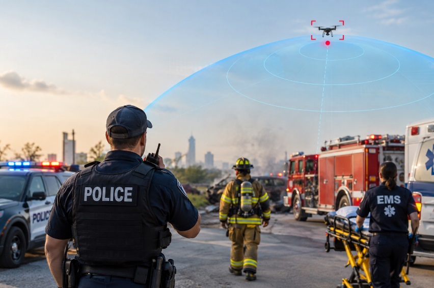
Drones are now part of the operating environment for U.S. public safety. They can support agency Drone-as-First-Responder programs, but they can also be used by criminals, harassers, or careless operators to observe, disrupt, or endanger an incident. Drone detection for first responders closes that information gap by providing real-time awareness of detectable drone activity before, during, and after crews arrive on scene.
For law enforcement, fire, and EMS, that awareness is not about treating every aircraft as a threat. It is about knowing what is in the air, separating authorized activity from unknown activity, and giving incident command time to make informed, lawful decisions.
Why Drone Detection Matters for U.S. First Responders
The rise of drones in public safety and criminal use
Public-safety agencies increasingly use drones for search and rescue, accident reconstruction, fireground assessment, and rapid aerial intelligence. At the same time, unauthorized drones can compromise tactical positions, interfere with fire operations, create hazards around crowds, or be used for contraband delivery. Remote ID makes many compliant drones more visible, but it does not mean every drone in the air will broadcast identifiable information.
Scene safety is not just ground-level anymore
A well-managed scene accounts for vehicles, people, weapons, weather, traffic, and structures. It must now account for the airspace directly above and around the incident as well. Drone detection for first responders gives command a faster way to identify detectable drone activity, assess its relationship to the incident, and share relevant information with dispatch and field personnel.
What Drone Detection for First Responders Actually Means
Remote ID versus non-Remote-ID drones
Remote ID is a broadcast capability used by many drones to transmit identification and location information. A Remote ID receiver may show a drone’s approximate position, altitude, and flight path; in appropriate cases, it may also provide control-station location data. Not every drone will provide that data. Custom-built, legacy, modified, or non-compliant aircraft may require other detection approaches, and no solution should promise detection of every possible aircraft.
Detection methods: RF, radar, optical/thermal, and AI
- RF detection listens for drone-related radio signals and can help identify supported aircraft and transmissions.
- Radar detects physical objects in the airspace and can add awareness where RF alone is insufficient.
- Optical and thermal cameras help operators visually confirm and track an aircraft.
- AI and multi-sensor fusion can correlate signals and reduce the amount of raw sensor activity an operator must interpret.
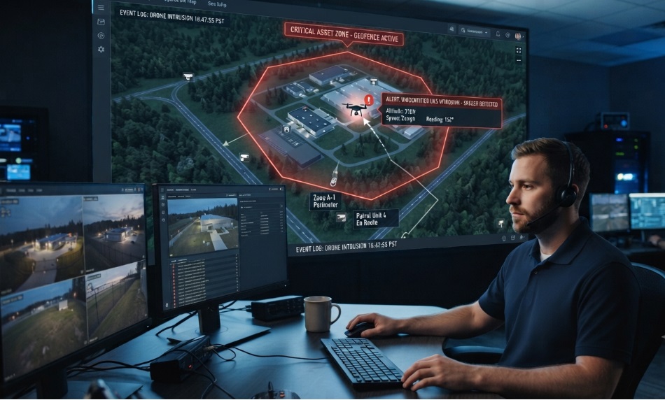
A useful platform can alert personnel that a detectable drone is present and provide available location, altitude, direction, identification, flight-path, and alert-history information. It cannot reliably reveal the identity or intent of every pilot, nor does a detection alert give a local agency authority to jam, spoof, take control of, or disable an aircraft.
How Detection Complements DFR Programs
DFR gives agencies eyes up; detection identifies other airspace activity
DFR programs launch an agency aircraft to provide rapid aerial video and thermal intelligence. Detection serves a different purpose: it monitors for other drones that may already be near the call. Combined, they help command manage both the agency’s own aircraft and unknown or unauthorized activity in the surrounding airspace.
Integrating alerts into CAD, radios, and command dashboards
An alert is most valuable when it reaches the people who can act on it. Agencies should route relevant drone alerts to the command dashboard, dispatch console, designated mobile units, or pre-established notification lists. The objective is not to overload radio traffic; it is to add airspace context to the same operating picture used for ground threats and resources.
Use Cases Across Law Enforcement, Fire, and EMS
Active calls and high-risk stops
During an active call, an unknown drone may reveal officer positions or create uncertainty around a perimeter. Detection can help command determine whether the activity is associated with an approved agency operation, a known partner, media, or an unknown operator who warrants further assessment.
Firegrounds and hazmat incidents
Fire command may already be using drones for thermal mapping or scene overview. An unauthorized aircraft can complicate aviation safety and distract responders. Detection supports early awareness and gives the incident commander an opportunity to coordinate with air operations and law enforcement before the situation escalates.
SWAT, barricades, and critical incidents
Tactical teams need to understand whether an aircraft is observing their positions, attempting to drop an object, or simply passing through the area. Detection data can support documentation, perimeter decisions, and communication with federal or regional partners when escalation is appropriate.
Public events, stadiums, and mass gatherings
Large events are an obvious use case because the consequence of a drone disruption can be high. Fixed monitoring, temporary mobile coverage, geofences, and approved-drone procedures can help security teams distinguish known flights from unexpected activity before it becomes a crowd-management issue.
Correctional facilities and contraband prevention
Correctional campuses are frequent targets for drone-delivered contraband. Detection around priority perimeters can alert staff to activity, preserve flight-path information, and improve coordination between facility security and law-enforcement partners.
Legal and Operational Boundaries in the U.S.
Detection data and lawful response
Passive detection and monitoring can provide valuable situational awareness. Agencies should use alerts within written policies that define who receives the data, how it is verified, how it is documented, and when an incident is referred to aviation, law-enforcement, or federal partners.
Mitigation, jamming, and federal restrictions
Detection is not mitigation. Actions such as jamming, spoofing, taking control of, or disabling a drone are tightly restricted under federal law and are generally not available to local and state public-safety agencies. A sound response model is detect, assess, document, coordinate, and escalate through lawful channels when necessary.
Privacy, policy, and public trust
Remote ID and related detection data can include sensitive location information. Agencies should establish retention rules, role-based access, audit practices, and clear use limitations. Publicly explaining the public-safety purpose of detection—particularly at events—can also support community trust.
Deployment Options for Public Safety Agencies
Fixed-site monitoring
Fixed sensors can provide continuous coverage around police facilities, fire headquarters, correctional sites, stadiums, public venues, or critical infrastructure. This model is appropriate when the location has recurring risk, regular events, or a need for persistent airspace awareness.
Mobile and vehicle-mounted detection
Mobile systems allow agencies to bring airspace awareness to an active operation, temporary event footprint, VIP movement, or disaster area. They are useful when the mission moves faster than a fixed infrastructure deployment can support.
Smartphone-based Remote ID awareness
A smartphone-based Remote ID tool can give field personnel an accessible way to check nearby compliant drone activity. AirSentinel’s mobile offering is positioned as an Android-based Remote ID sensor for real-time awareness. Agencies should confirm current device support, coverage expectations, and policy requirements before operational use.
A cloud platform can centralize fixed, mobile, and field-sensor data in one operational view. Useful functions include alerts, geofences, watchlists, historical review, user access controls, and SMS or email notifications. This model supports agencies that need multiple users, locations, or partner organizations to see the same airspace picture.
Building a Practical Response Workflow
1. Define the threat model
Identify the locations and missions where drone awareness has the most value. Consider public events, correctional facilities, high-risk calls, DFR launch areas, firegrounds, critical infrastructure, and recurring complaint locations.
2. Select the detection mix
Choose technology based on the environment and the agency’s actual need. Remote ID awareness may be sufficient for field-level checks, while recurring high-risk sites may require fixed, mobile, or multi-sensor coverage that can also identify selected non-Remote-ID activity.
3. Integrate alerts
Decide who receives an alert, where it appears, and what the initial response should be. Align notification rules with existing dispatch, command, and incident-management practices.
4. Train teams
Train dispatchers, supervisors, drone teams, and field personnel on alert interpretation. They should know the difference between confirmed information and unverified signal data, as well as their agency’s escalation procedures.
5. Review and refine
After deployments, review alert accuracy, response times, false-alarm patterns, and communication gaps. Use those findings to refine geofences, watchlists, notification thresholds, and SOPs.
Why AirSentinel for First Responders
AirSentinel provides drone detection and airspace-monitoring solutions for public safety, government, critical infrastructure, and related operational environments. Its product portfolio includes AMS solutions for real-time drone detection, cloud-based monitoring and alerts, and a mobile app for Remote ID awareness.
For first responders, the practical advantage is flexibility: agencies can start with field-level awareness, add fixed or mobile systems where risk justifies it, centralize alerts in a cloud platform, and expand users and monitoring areas as their program matures. Any deployment should be matched to the agency’s mission, environment, legal authority, and existing incident-command workflow.
Frequently Asked Questions
1) What is drone detection for first responders?
Drone detection for first responders uses sensors and software to monitor detectable drone activity around incidents, facilities, and events. It helps command assess available identification, location, and flight-path information without relying only on visual sightings.
2) How is drone detection different from Drone-as-First-Responder?
DFR launches an agency drone to provide aerial intelligence. Drone detection monitors for other detectable drones that may be operating nearby. Used together, they provide a more complete airspace picture.
3) Can drone detection identify drones without Remote ID?
Some systems can identify selected non-Remote-ID activity through RF analysis and other sensors. Performance varies by aircraft, environment, and technology, and no system can guarantee detection of every drone.
4) Can first responders jam or disable a detected drone?
Generally, no. Jamming, spoofing, control takeover, and other mitigation actions are tightly restricted under federal law. Most agencies should focus on detection, assessment, documentation, and lawful coordination.
5) What does a drone alert show?
Depending on the aircraft and sensor, an alert may show available drone identification, approximate position, altitude, direction, flight path, and, for certain Remote ID broadcasts, control-station location data.
6) Can detection be used at public events?
Yes. Fixed or mobile detection can help event-security teams monitor airspace, identify approved flights, flag unexpected activity, and follow pre-established response procedures.
7) How should an agency handle privacy?
Agencies should define permitted uses, access controls, retention periods, audit practices, and information-sharing rules. Clear policy and transparency support public trust.

 BLOG · SEP 22, 2026