A decade ago, “airspace security” was something only airports and military installations thought about. Today, a $500 consumer drone can fly over a stadium, a power substation, a correctional facility, or a VIP’s backyard, and most of the organizations responsible for protecting those spaces have no way of knowing it’s there until someone looks up. That gap is exactly why airspace monitoring has moved from a niche capability to a baseline expectation for security teams across a wide range of industries.
This isn’t a hypothetical risk. It’s a documented, accelerating trend with real regulatory and operational consequences, and understanding how airspace monitoring actually works is the first step to closing the gap.
What Airspace Monitoring Actually Means
Airspace monitoring is the continuous detection, identification, and tracking of low-altitude aircraft, almost always unmanned aircraft systems (UAS), or drones, within and around a defined area. Rather than relying on someone spotting a drone visually, a monitoring system uses sensors to detect a drone’s presence, classify what it is, and alert security personnel in real time, often with the drone’s location, altitude, and flight path.
It’s important to separate this from “counter-drone” in the broadest sense. Airspace monitoring is specifically the detection and awareness layer , it tells you a drone is there and what it’s doing. Whether and how to respond to that drone is a separate question, and one with real legal boundaries (more on that below).
Why Airspace Monitoring Has Become Urgent
The Numbers Behind the Trend
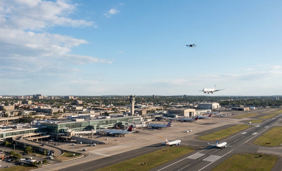
Unauthorized drone activity near U.S. airports isn’t a marginal issue anymore, it’s climbing fast. The FAA logged roughly 500 drone sightings near airports in 2023 alone. More recently, reports reviewed from FAA and NASA Aviation Safety Reporting System (ASRS) data showed 411 illegal drone incursions near U.S. airports in the first quarter of 2025, a jump of about 25.6% compared with the 327 reports recorded in the same period the year before.
These aren’t all near-misses in a technical sense, but some clearly were. Pilots have reported drones passing within just a few feet of aircraft during approach, and incidents involving commercial flights descending into major hubs have been serious enough for the FAA to classify them as high-risk encounters. A drone strike on a turbofan engine at high power, the kind of event that would occur during takeoff or landing, carries a real risk of engine damage, because a drone’s rigid battery and motor components don’t behave like the organic material engines are certified to withstand from bird strikes.
What’s Driving the Increase
Several forces are converging at once: drones are cheaper and more capable than ever, commercial and hobbyist adoption keeps growing, and low-altitude airspace the space where most of this activity happens has historically had the least visibility and the least regulation. On top of that, FAA Remote ID requirements now mean most drones broadcast identifying information, which has actually made monitoring more effective, since a well-designed system can pick up that signal and identify a drone’s operator information without needing to physically intercept anything.
Put together, the result is a security blind spot that didn’t exist fifteen years ago and now affects a wide swath of American infrastructure from airports to power plants and water treatment facilities to stadiums hosting tens of thousands of people.
How Modern Airspace Monitoring Works
Airspace monitoring systems generally combine one or more detection methods, depending on the environment, budget, and level of assurance required.
Radio Frequency (RF) Detection
Most consumer and commercial drones communicate with their controller over radio frequencies. RF sensors passively listen for these signals, which allows them to detect a drone and often its controller’s approximate location without emitting any signal of their own. RF detection tends to be the most cost-effective starting point because it requires no active transmission and can cover a wide area from a single sensor.
Radar-Based Detection
Radar systems actively scan for objects in the airspace and can detect drones that aren’t broadcasting a controllable RF signal, including some autonomous or pre-programmed flights. Radar is typically layered on top of RF detection in higher-security environments like military installations or major airports, where the cost of a missed detection is highest.
Remote ID and Cooperative Tracking
Since most drones now broadcast Remote ID the FAA-mandated digital “license plate” that includes the drone’s identity, location, altitude, and take-off point a monitoring system that can read Remote ID signals gets a significant head start. It’s the difference between detecting an anomaly and immediately knowing what you’re looking at.
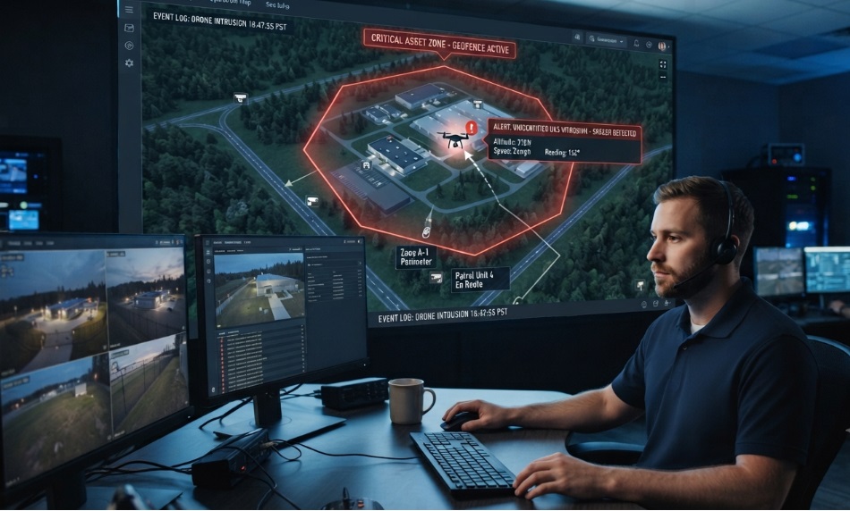
Detection hardware is only half the system. The other half is the software layer that turns raw sensor data into something a security team can actually act on: a live map of the airspace, custom geofences around sensitive zones, watchlists for known or repeat offenders, and instant alerts the moment a drone crosses into restricted space. A cloud-based platform also means multiple sites, agencies, or partner organizations can share the same real-time picture instead of operating in isolation.
Detection vs. Mitigation: Where the Legal Line Sits
This is where many buyers get confused, and it’s worth being direct. Under U.S. federal law, actively interfering with a drone in flight jamming its signal, taking control of it, or physically bringing it down is restricted to a small number of authorized federal agencies. Most commercial organizations, including airport operators, stadiums, and private security teams, are legally limited to detection, identification, and alerting.
That’s not a limitation of the technology; it’s a deliberate regulatory boundary designed to prevent interference with legitimate aircraft, GPS systems, and communications. In practice, this means the value of an airspace monitoring system for most organizations isn’t stopping a drone it’s giving security personnel enough warning and information (location, flight path, sometimes operator data) to notify law enforcement, evacuate an area, or activate an internal response plan before a drone becomes a real problem.
Who Needs Airspace Monitoring
While airports remain the highest-profile use case, the same underlying risk an unseen aircraft in restricted or sensitive airspace applies well beyond aviation:
- Airports protecting approach and departure paths from disruptive or dangerous incursions
- Critical infrastructure power grids, water treatment plants, and telecom sites vulnerable to surveillance or sabotage
- Public events and stadiums large crowds concentrated in a single, predictable location
- Maritime and port facilities shipping hubs and cargo operations exposed to aerial surveillance
- Correctional facilities a well-documented channel for contraband drops
- Military and government sites sensitive operations where aerial surveillance carries national security implications
- Law enforcement and first responders needing real-time situational awareness during active incidents
Each of these environments has different coverage needs, but the underlying question is the same: is there any way to know a drone has entered the airspace before someone sees or hears it?
What to Look for in an Airspace Monitoring System
Not every organization needs military-grade radar. But a few criteria apply almost universally when evaluating a system:
- Detection method fit: RF alone may be sufficient for many sites; higher-risk environments benefit from layered RF and radar coverage.
- Remote ID compatibility: a system that reads Remote ID gets identifying information most passive detection can’t.
- Deployment complexity : fixed hardware installations versus mobile, rapid-deployment sensors for temporary events.
- Scalability and licensing: whether the platform charges per user or per sensor, which matters as coverage or team size grows.
- Alerting and geofencing: how quickly and clearly the system notifies personnel, and whether custom no-fly zones can be configured per site.
- Ease of operation: whether the system requires a dedicated technical team or can be run by existing security staff.
Getting Started with Airspace Monitoring
For most organizations, the practical starting point is a combination of fixed or mobile sensors like AirSentinel’s AMS sensors feeding into a centralized dashboard that gives security teams a single, real-time view of the airspace. Organizations that want to evaluate the basics before committing to hardware can also start with the AirSentinel mobile app, which detects Remote ID drones directly from a phone at no cost.
Whatever the entry point, the underlying goal is the same: replace “we’ll notice if a drone shows up” with a system that tells you the moment one does.
FAQs
1) What is airspace monitoring?
Airspace monitoring is the continuous detection, identification, and tracking of drones and other low-altitude aircraft within a defined area, typically using RF, radar, or Remote ID-based sensors paired with real-time alerting software.
2) Is airspace monitoring the same as drone detection?
They’re closely related. Drone detection usually refers to the sensor technology itself, while airspace monitoring describes the broader, ongoing practice of watching and managing the airspace using that technology.
3) Can a business legally take down a drone it detects?
No. In the U.S., only specific authorized federal agencies can actively disable, jam, or capture a drone. Commercial organizations are generally limited to detection, tracking, and alerting authorities.
4) What is Remote ID and why does it matter for monitoring?
Remote ID is an FAA requirement that most drones broadcast identifying information, including location, altitude, and take-off point, similar to a digital license plate. Monitoring systems that read Remote ID can identify a drone immediately rather than just detecting an unknown object.
5) Which industries need airspace monitoring the most?
Airports, critical infrastructure, public events and stadiums, correctional facilities, maritime and port operations, and military or government sites all face meaningful exposure from unauthorized drone activity.
6) How much does an airspace monitoring system cost?
Costs vary widely based on sensor type, coverage area, and whether the platform charges per user. Some tools, like basic Remote ID detection apps, are available at no cost, while enterprise-grade sensor networks with radar and multi-site cloud dashboards represent a larger investment.
7) Do I need a technical team to run an airspace monitoring system?
Not necessarily. Many modern platforms are built for security teams without dedicated IT staff, with straightforward sensor installation and app-guided setup.

 BLOG · SEP 22, 2026